← Back to sales in Franklin

All sales / TN / Franklin

Online auction in Franklin, TN: Nov 14

Online auction in Franklin, TN, photo 1Online auction in Franklin, TN, photo 2Online auction in Franklin, TN, photo 3Online auction in Franklin, TN, photo 4Online auction in Franklin, TN, photo 5Online auction in Franklin, TN, photo 6Online auction in Franklin, TN, photo 7Online auction in Franklin, TN, photo 8Online auction in Franklin, TN, photo 9Online auction in Franklin, TN, photo 10Online auction in Franklin, TN, photo 11Online auction in Franklin, TN, photo 12

Photos: Trillium Antique Prints & Rare Books via EstateSales.NET · 50 photos in the full listing

WhenSat, Nov 14 · 9:00 AM–11:59 PM
PickupFranklin, TN 37069 (exact address not listed yet)
Run byTrillium Antique Prints & Rare Books

View original listing on EstateSales.NET ↗

Best finds in the photos

Antique 19th-century hand-colored lithograph of a tropical coastal valley with figures and stone walls, likely from a travel or voyage book plate
Art & Paintings

Antique 19th-century hand-colored lithograph of a tropical coastal valley with figures and stone walls, likely from a travel or voyage book plate

Antique 19th-century lithograph print of a harbor town with a church spire and sailing ships
Art & Paintings

Antique 19th-century lithograph print of a harbor town with a church spire and sailing ships

Antique black-and-white lithograph landscape print with horse-drawn carriage and river scene, circa 1830-1850
Art & Paintings

Antique black-and-white lithograph landscape print with horse-drawn carriage and river scene, circa 1830-1850

Antique black-and-white lithograph print of a wooden bridge over a river with grazing horses, likely early-to-mid 19th century European (Biedermeier-style landscape)
Art & Paintings

Antique black-and-white lithograph print of a wooden bridge over a river with grazing horses, likely early-to-mid 19th century European (Biedermeier-style landscape)

Antique hand-colored lithograph, 19th-century expedition landscape plate with explorers, tent, and horses
Art & Paintings

Antique hand-colored lithograph, 19th-century expedition landscape plate with explorers, tent, and horses

Hand-painted watercolor plate of Nestor notabilis (Kea), male, signed J.R.I. del. 26-7-45
Art & Paintings

Hand-painted watercolor plate of Nestor notabilis (Kea), male, signed J.R.I. del. 26-7-45

Lot of 4 antique 1903 Bulletin of the U.S. Fish Commission fish lithograph plates (Malthopsis jordani, Chaetodon unimaculatus, Lagocephalus oceanicus, Ostracion schlemmeri), Julius Bien & Co. printers
Art & Paintings

Lot of 4 antique 1903 Bulletin of the U.S. Fish Commission fish lithograph plates (Malthopsis jordani, Chaetodon unimaculatus, Lagocephalus oceanicus, Ostracion schlemmeri), Julius Bien & Co. printers

19th century hand-colored lithograph of a tropical harbor town with sailing ships, outrigger canoes, and rafts
Art & Paintings

19th century hand-colored lithograph of a tropical harbor town with sailing ships, outrigger canoes, and rafts

Everything we spotted, photo by photo

53 items identified in 48 of the listing photos.

Antique 19th-century hand-colored lithograph of a tropical coastal valley with figures and stone walls, likely from a travel or voyage book plate
  • Antique 19th-century hand-colored lithograph of a tropical coastal valley with figures and stone walls, likely from a travel or voyage book plate
Antique 19th-century lithograph print of a harbor town with a church spire and sailing ships
  • Antique 19th-century lithograph print of a harbor town with a church spire and sailing ships
Antique black-and-white lithograph landscape print with horse-drawn carriage and river scene, circa 1830-1850
  • Antique black-and-white lithograph landscape print with horse-drawn carriage and river scene, circa 1830-1850
Antique black-and-white lithograph print of a wooden bridge over a river with grazing horses, likely early-to-mid 19th century European (Biedermeier-style landscape)
  • Antique black-and-white lithograph print of a wooden bridge over a river with grazing horses, likely early-to-mid 19th century European (Biedermeier-style landscape)
Antique hand-colored lithograph, 19th-century expedition landscape plate with explorers, tent, and horses
  • Antique hand-colored lithograph, 19th-century expedition landscape plate with explorers, tent, and horses
Hand-painted watercolor plate of Nestor notabilis (Kea), male, signed J.R.I. del. 26-7-45
  • Hand-painted watercolor plate of Nestor notabilis (Kea), male, signed J.R.I. del. 26-7-45
Lot of 4 antique 1903 Bulletin of the U.S. Fish Commission fish lithograph plates (Malthopsis jordani, Chaetodon unimaculatus, Lagocephalus oceanicus, Ostracion schlemmeri), Julius Bien & Co. printers
  • Lot of 4 antique 1903 Bulletin of the U.S. Fish Commission fish lithograph plates (Malthopsis jordani, Chaetodon unimaculatus, Lagocephalus oceanicus, Ostracion schlemmeri), Julius Bien & Co. printers
19th century hand-colored lithograph of a tropical harbor town with sailing ships, outrigger canoes, and rafts
  • 19th century hand-colored lithograph of a tropical harbor town with sailing ships, outrigger canoes, and rafts
Giovanni Battista Piranesi etching, Veduta di palazzo in Rome, from Vedute di Roma, 18th century, hand-tinted impression
  • Giovanni Battista Piranesi etching, Veduta di palazzo in Rome, from Vedute di Roma, 18th century, hand-tinted impression
Giovanni Battista Piranesi etching, view of Santa Maria Maggiore, Rome, 18th century (Vedute di Roma style)
  • Giovanni Battista Piranesi etching, view of Santa Maria Maggiore, Rome, 18th century (Vedute di Roma style)
1744 antique engraved map 'Carte de l'Accadie' (Acadia), by N.B. Ingr. et Hyd. de la Marine, after Dépôt des Cartes et Plans de la Marine manuscripts
  • 1744 antique engraved map 'Carte de l'Accadie' (Acadia), by N.B. Ingr. et Hyd. de la Marine, after Dépôt des Cartes et Plans de la Marine manuscripts
1744 antique engraved map 'Partie de la Coste de la Louisiane et de la Floride' by N.B. (Nicolas Bellin), Gulf Coast from Mississippi to St. Marc d'Apalache
  • 1744 antique engraved map 'Partie de la Coste de la Louisiane et de la Floride' by N.B. (Nicolas Bellin), Gulf Coast from Mississippi to St. Marc d'Apalache
Antique 1500s-1600s woodcut map of Sardinia from Sebastian Münster's Cosmographia (Das Ander Buch, Ptolemaic Sardinia tavola)
  • Antique 1500s-1600s woodcut map of Sardinia from Sebastian Münster's Cosmographia (Das Ander Buch, Ptolemaic Sardinia tavola)
Antique 15th-century German woodcut book page with hand-set blackletter text and illustrations of comets, rain, and monstrous figures, Hartmann Schedel Nuremberg Chronicle 1493 woodcut book leaves (Das sechst alter / Blatt CXCVIII), two pages with woodcut illustrations of Carmelite and Crusader orders, Saint Bernhard, Pope Pius II (Petrus Alfonsus), and Tartar empire
  • Antique 15th-century German woodcut book page with hand-set blackletter text and illustrations of comets, rain, and monstrous figures
  • Hartmann Schedel Nuremberg Chronicle 1493 woodcut book leaves (Das sechst alter / Blatt CXCVIII), two pages with woodcut illustrations of Carmelite and Crusader orders, Saint Bernhard, Pope Pius II (Petrus Alfonsus), and Tartar empire
Antique 1744 copper-engraved map 'Plan de la Baye de Pansacola' (Pensacola Bay) by N.B., engraved by Dheulland, French Naval engineer, from Bellin/Le Rouge-era atlas
  • Antique 1744 copper-engraved map 'Plan de la Baye de Pansacola' (Pensacola Bay) by N.B., engraved by Dheulland, French Naval engineer, from Bellin/Le Rouge-era atlas
Antique 1744 engraved map 'Plan du Port Royal dans l'Accadie, Appellé aujourd'hui par les Anglois Annapolis Royale' by N.B. Ing. de la M., engraved by D. Heulland (Dheulland Sculp)
  • Antique 1744 engraved map 'Plan du Port Royal dans l'Accadie, Appellé aujourd'hui par les Anglois Annapolis Royale' by N.B. Ing. de la M., engraved by D. Heulland (Dheulland Sculp)
Antique 1747 engraved copperplate map of the Mediterranean and Adriatic Seas by Emanuel Bowen, geographer to His Majesty, Vol. II page 725
  • Antique 1747 engraved copperplate map of the Mediterranean and Adriatic Seas by Emanuel Bowen, geographer to His Majesty, Vol. II page 725
Antique 1785 Venice hand-colored copperplate map 'Chili, la Terra Magellanica, coll'Isola della Terra del Fuoco' by Antonio Zatta
  • Antique 1785 Venice hand-colored copperplate map 'Chili, la Terra Magellanica, coll'Isola della Terra del Fuoco' by Antonio Zatta
Antique 17th-century Dutch engraved sea chart 'Mare Germanicum' of the North Sea, British Isles and Scandinavia by R. & J. Ottens, Amsterdam
  • Antique 17th-century Dutch engraved sea chart 'Mare Germanicum' of the North Sea, British Isles and Scandinavia by R. & J. Ottens, Amsterdam
Antique 18th c. Dutch engraved sea chart 'Mare Germanicum' / Pascaert van de Noord Zee, Ameland to the Hoofden, after L. Renard, Amsterdam
  • Antique 18th c. Dutch engraved sea chart 'Mare Germanicum' / Pascaert van de Noord Zee, Ameland to the Hoofden, after L. Renard, Amsterdam
Antique 18th century copper-engraved map of Asia, 'A New & Exact Map of Asia' by Tho. Bowen, Geographer to His Majesty, Vol. II page 790 (c. 1747-1752)
  • Antique 18th century copper-engraved map of Asia, 'A New & Exact Map of Asia' by Tho. Bowen, Geographer to His Majesty, Vol. II page 790 (c. 1747-1752)
Antique 18th-century French engraved map 'Carte des Costes de la Floride Françoise' by N. Bellin, Carolinas and Georgia coast, Paris c. 1760s
  • Antique 18th-century French engraved map 'Carte des Costes de la Floride Françoise' by N. Bellin, Carolinas and Georgia coast, Paris c. 1760s
Antique Dutch sea chart Norvegiae Maritimae (Pascaert van Noorwegen), Norway coast, engraved, likely Van Keulen c. 1700s-1720s
  • Antique Dutch sea chart Norvegiae Maritimae (Pascaert van Noorwegen), Norway coast, engraved, likely Van Keulen c. 1700s-1720s
Antique engraved bird's-eye city view map of Messina, Sicily, from Braun & Hogenberg Civitates Orbis Terrarum (late 16th century, c. 1572-1618)
  • Antique engraved bird's-eye city view map of Messina, Sicily, from Braun & Hogenberg Civitates Orbis Terrarum (late 16th century, c. 1572-1618)
Antique engraved city map of Bamberg, Germany, 'Bambergae Episcopalis in Franconiae urbis celeberrimae typus' with coat of arms of Johannes Philippus, Prince-Bishop of Bamberg, 17th century copperplate engraving
  • Antique engraved city map of Bamberg, Germany, 'Bambergae Episcopalis in Franconiae urbis celeberrimae typus' with coat of arms of Johannes Philippus, Prince-Bishop of Bamberg, 17th century copperplate engraving
Antique engraved map of Marco Polo's Voyages & Travels in the 13th Century through Asia, all Tartary, East India Islands & part of Africa, Vol. I page 593 (18th century copper engraving, likely late 1700s London publication)
  • Antique engraved map of Marco Polo's Voyages & Travels in the 13th Century through Asia, all Tartary, East India Islands & part of Africa, Vol. I page 593 (18th century copper engraving, likely late 1700s London publication)
Antique hand-colored copper engraving of Canis corsac Linn (corsac fox), plate XCI B, Schreber Die Säugthiere style, 18th century, Antique hand-colored copper engraving of Canis virginianus (Virginia fox/grey fox), plate XCII B, Schreber Die Säugthiere style, 18th century
  • Antique hand-colored copper engraving of Canis corsac Linn (corsac fox), plate XCI B, Schreber Die Säugthiere style, 18th century
  • Antique hand-colored copper engraving of Canis virginianus (Virginia fox/grey fox), plate XCII B, Schreber Die Säugthiere style, 18th century
Antique hand-colored copper engraving, Didelphys Brunii (wallaby), plate CLIII, C. le Brun del., I. Nussbiegel sc., late 18th century, Antique hand-colored copper engraving, Didelphys gigantea (kangaroo), plate CLIV, after Schreber's Die Säugthiere, I. Nussbiegel sc., late 18th century
  • Antique hand-colored copper engraving, Didelphys Brunii (wallaby), plate CLIII, C. le Brun del., I. Nussbiegel sc., late 18th century
  • Antique hand-colored copper engraving, Didelphys gigantea (kangaroo), plate CLIV, after Schreber's Die Säugthiere, I. Nussbiegel sc., late 18th century
Antique hand-colored copper-engraved map 'Brabantiae Ducatus S.R. Imperii Marchionatus Mechliniae... Nova Tabula' by F. de Wit, Amsterdam, c. 1700
  • Antique hand-colored copper-engraved map 'Brabantiae Ducatus S.R. Imperii Marchionatus Mechliniae... Nova Tabula' by F. de Wit, Amsterdam, c. 1700
Antique hand-colored copper-engraved map 'Carte de la Prévosté et Vicomté de Paris' by Guillaume de l'Isle, published Amsterdam by Covens & Mortier, early 18th century
  • Antique hand-colored copper-engraved map 'Carte de la Prévosté et Vicomté de Paris' by Guillaume de l'Isle, published Amsterdam by Covens & Mortier, early 18th century
Antique hand-colored copper-engraved map 'Carte des Provinces Unies des Pays Bas' (Belgium Foederatum) by G. De L'Isle, Amsterdam, Jean Covens & Corneille Mortier, c. 1730s-1740s
  • Antique hand-colored copper-engraved map 'Carte des Provinces Unies des Pays Bas' (Belgium Foederatum) by G. De L'Isle, Amsterdam, Jean Covens & Corneille Mortier, c. 1730s-1740s
Antique hand-colored copper-engraved map 'Insularum Sardiniae et Corsicae Descriptio' by Frederick de Wit, Amsterdam, late 17th century
  • Antique hand-colored copper-engraved map 'Insularum Sardiniae et Corsicae Descriptio' by Frederick de Wit, Amsterdam, late 17th century
Antique hand-colored copper-engraved map Marchionatus Brandenburgi et Ducatus Pomeraniae by Frederick de Wit, Amsterdam, c. 1680-1700
  • Antique hand-colored copper-engraved map Marchionatus Brandenburgi et Ducatus Pomeraniae by Frederick de Wit, Amsterdam, c. 1680-1700
Antique hand-colored copper-engraved map of Europe, 'Totius Europae Littora Nordsini Oris' by Robert de Vaugondy/Johannes van Keulen style, Amsterdam (Van Keulen sea chart, circa late 1600s-early 1700s), with compass roses and decorative cartouches
  • Antique hand-colored copper-engraved map of Europe, 'Totius Europae Littora Nordsini Oris' by Robert de Vaugondy/Johannes van Keulen style, Amsterdam (Van Keulen sea chart, circa late 1600s-early 1700s), with compass roses and decorative cartouches
Antique hand-colored copper-engraved sea chart of the Canary Islands by Hendrick Doncker, Amsterdam, 17th century (Canarische Eylanden, Canaria, Tenerifa, Fuerteventura, Lanzarote)
  • Antique hand-colored copper-engraved sea chart of the Canary Islands by Hendrick Doncker, Amsterdam, 17th century (Canarische Eylanden, Canaria, Tenerifa, Fuerteventura, Lanzarote)
Antique hand-colored copperplate city view map of Groningen (Groninga), Braun & Hogenberg Civitates Orbis Terrarum style, late 16th century
  • Antique hand-colored copperplate city view map of Groningen (Groninga), Braun & Hogenberg Civitates Orbis Terrarum style, late 16th century
Antique hand-colored copperplate engraved map of Kalkar (Calcaria), Duchy of Cleves, from Braun & Hogenberg Civitates Orbis Terrarum, late 16th century
  • Antique hand-colored copperplate engraved map of Kalkar (Calcaria), Duchy of Cleves, from Braun & Hogenberg Civitates Orbis Terrarum, late 16th century
Antique hand-colored copperplate engraved map of Southern South America, Strait of Magellan and Río de la Plata, Tractus Australior Americae Meridionalis, by Johannes van Keulen (Dutch, c. 1700s), with decorative cartouche and naval battle vignette
  • Antique hand-colored copperplate engraved map of Southern South America, Strait of Magellan and Río de la Plata, Tractus Australior Americae Meridionalis, by Johannes van Keulen (Dutch, c. 1700s), with decorative cartouche and naval battle vignette
Antique hand-colored Dutch copper-engraved sea chart 'Pascaart vertoonende de zeekusten van Chili, Peru, Hispania Nova, Nova Granada, en California' by Hendrick Doncker, 's Amsterdam, late 17th/early 18th century
  • Antique hand-colored Dutch copper-engraved sea chart 'Pascaart vertoonende de zeekusten van Chili, Peru, Hispania Nova, Nova Granada, en California' by Hendrick Doncker, 's Amsterdam, late 17th/early 18th century
Antique hand-colored woodcut map 'Das Heilig Judenland' Holy Land with twelve tribes, German Renaissance, likely Sebastian Münster Cosmographia 16th century
  • Antique hand-colored woodcut map 'Das Heilig Judenland' Holy Land with twelve tribes, German Renaissance, likely Sebastian Münster Cosmographia 16th century
Lot of 2 antique hand-colored bear engravings, Ursus Arctos niger (black bear) and Ursus maritimus (polar bear), plates CXL and CXLI, late 18th century, from a Schreber-style mammal book
  • Lot of 2 antique hand-colored bear engravings, Ursus Arctos niger (black bear) and Ursus maritimus (polar bear), plates CXL and CXLI, late 18th century, from a Schreber-style mammal book
1774 hand-colored copper engraving of domestic and Angora cats, Felis Catus Linn. domesticus and Angorensis, plate CVII B, engraved by Joh. Nussbiegel (Schreber natural history series), 1774 hand-colored copper engraving of wildcat, Felis Catus Linn. ferus, plate CVII Aa, after D.R. Nitschmann, engraved by I. Nussbiegel (Schreber natural history series)
  • 1774 hand-colored copper engraving of domestic and Angora cats, Felis Catus Linn. domesticus and Angorensis, plate CVII B, engraved by Joh. Nussbiegel (Schreber natural history series)
  • 1774 hand-colored copper engraving of wildcat, Felis Catus Linn. ferus, plate CVII Aa, after D.R. Nitschmann, engraved by I. Nussbiegel (Schreber natural history series)
1785 Antonio Zatta hand-colored copper engraved map 'La Terra Ferma, La Gujana Spagnola, Olandese, Francese, e Portughese, e la parte settentrionale del Bresil' (Venezia)
  • 1785 Antonio Zatta hand-colored copper engraved map 'La Terra Ferma, La Gujana Spagnola, Olandese, Francese, e Portughese, e la parte settentrionale del Bresil' (Venezia)
17th-century Dutch hand-colored copper-engraved map of the Bight of Benin (Pascaert vande Bocht van Benin, Tary Ardra en Rio de Lagos, van Ardra tot C. Formosa), by Joannes van Keulen, Amsterdam
  • 17th-century Dutch hand-colored copper-engraved map of the Bight of Benin (Pascaert vande Bocht van Benin, Tary Ardra en Rio de Lagos, van Ardra tot C. Formosa), by Joannes van Keulen, Amsterdam
Hartmann Schedel Nuremberg Chronicle 1493 woodcut page, 'Das sechst alter' with Mahomet and Isidorus/Goar woodcut portraits
  • Hartmann Schedel Nuremberg Chronicle 1493 woodcut page, 'Das sechst alter' with Mahomet and Isidorus/Goar woodcut portraits
Johannes van Keulen 'Pascaart van Galissien en Portugal' hand-colored copper-engraved sea chart, Amsterdam, c. 1700-1720
  • Johannes van Keulen 'Pascaart van Galissien en Portugal' hand-colored copper-engraved sea chart, Amsterdam, c. 1700-1720
Lot of 2 loose leaves from Hartmann Schedel's Nuremberg Chronicle (Liber Chronicarum) 1493, woodcut illustrated pages CLXXIII and 'Das sechst alter', German text
  • Lot of 2 loose leaves from Hartmann Schedel's Nuremberg Chronicle (Liber Chronicarum) 1493, woodcut illustrated pages CLXXIII and 'Das sechst alter', German text
Nuremberg Chronicle 1493 German edition woodcut leaf, Constantinople city view (Blatt CCXLIX), Nuremberg Chronicle 1493 German edition woodcut leaf, Eichstatt city view (Blatt CLXII)
  • Nuremberg Chronicle 1493 German edition woodcut leaf, Constantinople city view (Blatt CCXLIX)
  • Nuremberg Chronicle 1493 German edition woodcut leaf, Eichstatt city view (Blatt CLXII)

More sales in Franklin this weekend (4)

Nov 6–8 · See all 4 sales in Franklin →

Moving sale in Franklin, TN: Adjustable overbed rolling bedside table with wood topFri–Sat · 8 AMMoving saleSimilar listed ~$376

Franklin, TN 37064

Adjustable overbed rolling bedside table with wood top · AIXPI hand grip strength trainer · Aluminum step ladder, 5-step, painted and worn

Photo: Busy Bee Moving Sales via EstateSales.NET

Estate sale in Franklin, TN: 1766 hand-colored copper engraved map 'L'Amerique Meridionale et Septentrionale' by L.C. Desnos, Paris, after Guillaume Delisle, Sieur de LisleSat · 9 AMEstate saleSimilar listed ~$950

Franklin, TN 37069

1766 hand-colored copper engraved map 'L'Amerique Meridionale et Septentrionale' by L.C. Desnos, Paris, after Guillaume Delisle, Sieur de Lisle · 1797 Italian copperplate engraved map of the United States 'Gli Stati Uniti dell'America' Quarto Foglio by Antonio Zatta / Calcografia Camerale, Rome, hand-colored, showing New England, New York, Pennsylvania, Delaware, Maryland, Virginia and Carolina · 17th-century Dutch hand-colored sea chart 'Pas Caart van de Canaal tusschen Engeland en Vrancrijck' by Hendrick Doncker, Amsterdam (English Channel, c. 1660s-1680s)

Photo: Trillium Antique Prints & Rare Books via EstateSales.NET

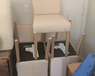
Estate sale in Franklin, TN: Lot of 4 cream upholstered bar stools with light wood legs, new in boxSat–SunEstate sale

Franklin, TN 37069

Lot of 4 cream upholstered bar stools with light wood legs, new in box

Photo: gsalr

Sat–Sun · 8 AMEstate sale

Franklin, TN 37069

Before you go

Item names come from our analysis of the listing photos, so they can be wrong. Auction lots close online; pickup is at the location above. Check the organizer's listing for last-minute changes. More sales in Franklin.

How this data is collected · Get alerts for new sales on the Spotted app